with Mom
Dedicated to my late Mother and her spirit of adventure.
Mom came to visit about half a year after I moved to California. I wanted to show her my new home state, but didn't have any vacation time, so we crammed a lot into two weekend trips. On this trip, we started off early Saturday morning in my fastest car, a 1979 BMW 323i, and headed east towards the mountains.
 |
Our first destination was
Sequoia & Kings Canyon National Parks.
Just past the entrance gate, we stopped for several hours to hike the
Big Stump Trail.
We then drove a bit more to the
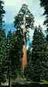
General Grant Grove,
home of the
General Grant Tree,
our
Nation's Christmas Tree.
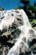
After a bite to eat at the visitor's center, we continued along CA 180 into Kings Canyon, finally stopping at Grizzly Falls, which is actually outside the park boundaries in Sequoia National Forest. After that, we started back towards General Grant Grove and then down Generals Highway into the main part of Sequoia National Park. It was dusk by the time we reached the General Sherman Tree, and we had big plans for the next morning and many miles to drive, so we paused only briefly before continuing on. |
 |
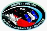 |
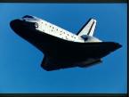
Mom had long been fascinated by NASA and the manned space program,
and it happened that Space Shuttle Mission
STS-31
was busy deploying the
Hubble Space Telescope
during Mom's visit.
Discovery (OV-103)
and its crew of five were scheduled to land at
Edwards AFB
early Sunday morning.
Driving through the evening, we reached Mojave well after midnight,
only to find that our "guaranteed late arrival" room had been given away.
|
|||
|
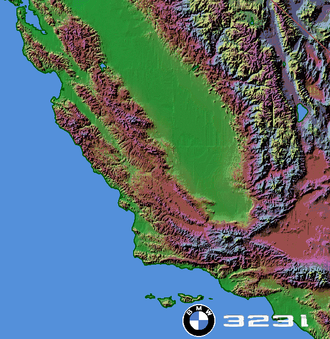
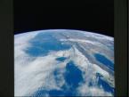
With no rooms available anywhere else in town, we drove out to survey what awaited us the next morning, and found many people already camped out at the viewing area alongside 7.5-mile runway 17 on Rogers Dry Lake. We parked and slept in the car, waking occasionally to fire up the engine for some heat. Deserts can be cold! Meanwhile, Discovery's crew was busy taking some final photographs, including this one of California and surrounding areas. |
 |
|||
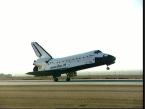
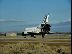
The mission plan had Discovery landing on runway 17, which would have given us a ringside seat, but weather conditions caused a change to the concrete main runway, 15,000-foot long runway 22. Our vantage point wasn't nearly as good, but it was the best we could do without VIP passes. We still heard the characteristic double sonic boom as Discovery made a sweeping left turn overhead, and saw it complete its incredibly fast and steep final approach and then its rollout in the distance. Simply being there to experience it was itself a tremendous thrill.
 |
 |
 |
||
| (Complete compendium of STS-31 images) | ||||
 |
Having witnessed some very advanced transportation technology and how
it quickly dealt with a large change in elevation, we hopped back in the
car for a realtively short drive to see how a significant elevation change
was addressed more than 100 years earlier.
 The Tehachapi Loop
is located on the western side of Tehachapi Pass along the
Southern Pacific Railroad's mainline from Bakersfield to Mojave,
at a point where the railroad needed to gain 77 feet in minimal
distance. To solve this problem, chief engineer William Hood had the
track loop around to cross over itself.
The Tehachapi Loop
is located on the western side of Tehachapi Pass along the
Southern Pacific Railroad's mainline from Bakersfield to Mojave,
at a point where the railroad needed to gain 77 feet in minimal
distance. To solve this problem, chief engineer William Hood had the
track loop around to cross over itself.
We stopped at the location of California Historical Landmark No. 508, from where your line of sight crosses the tracks five times. It's a great place to watch trains, and as the busiest single-track railroad in the world there are plenty of them, though the days of the 1957 San Joaquin Daylight in the animated map are long gone. Even the Southern Pacific and Santa Fe freights from the time of our visit are gone; today's trains are run by the Union Pacific and BNSF. |
| From there, we continued west on CA 58, which west of McKittrick turned out to be considerably more twisty than our map had led us to expect. It was a fun drive, though we were eager to reach the coast and Big Sur. At its end, we turned north to Atascadero, then west on CA 41, which turned out to be very pretty. We stopped briefly at an avocado farm, something which neither of us had ever seen before. |  |
 |
 |
We finally reached the ocean late in the afternoon, and turned north for Mom's first visit to Big Sur. The waning light of the day turned out to be quite dramatic, enhancing the beauty of one of the world's most scenic stretches of highway. After dark, we stopped in Carmel for dinner at the Hog's Breath Inn before completing our journey back to San Jose. |
 Copyright © 2002-2003,2005,2008,2022, Karl L. Swartz. All rights reserved.
All trademarks mentioned herein belong to their respective owners.
Grizzly Falls photo courtesy Jessica Gorin, from her
Sequoia and Kings Canyon Trip.
Highway marker signs courtesy
Mike Wiley's Road Geek Pages.
Road name and information signs generated using
Kurumi's SignMaker.
Reconnaissance imagery courtesy the
U.S. Geological Survey via Micro$oft's
TerraServer.